
While most people are familiar with Minnesota's 10,000 lakes, there's only one that should be apart of your next sojourn: Lake Superior. The largest freshwater lake in the world doesn't get much attention from the photo world. Whether it be it's landlocked status in a sparsely populated area of the United States, or the fact that it's freezing the majority of the year, it's not nearly photographed as much as it deserves.
This blog is going to focus on Lake Superior's North Shore (stateside) which extends from Duluth to Grand Portage. I've made two trips up the shore this year, one in the summer, and one in winter, so this post is going to exhibit the best of both worlds. Both of my excursions were day trips, so the agenda I'm about the outline will focus on the best way to spend one day on the North Shore. Here we go...

Starting Point: Duluth, Minnesota
Duluth is on the up, and up. That's for sure. The town of about 86,000, located on the westernmost point of the Great Lakes is almost always listed in top 5 of best towns to live in the United States. With a growing culture, and beautiful scenery, the town is a can't miss. It's also the southern terminus of the Superior Hiking Trail, which is a 310 mile long trail that follows follows Superior's shoreline north towards Grand Portage.
Anyways, Duluth is the perfect starting point for any North Shore excursion as there are plenty of places to eat (Canal Park Brewery is my recommendation), lodging is inexpensive, and the town has an all-around great vibe.
Summer:


Winter:


Things That You'll Need:
Summer:
- Hiking Boots - Don't need anything too crazy, athletic shoes would work, too.
- Bug Spray- Something with Deet in it because the ticks can be bad
- Layers- Sweater in the morning, that you're going to need to take off later in the day
- Water / Food - Once you're north of Two Harbors there aren't too many places to grab food
Winter:
- Lots of layers - Down jacket, wool socks, snow pants, etc.
- Extra camera batteries - Your camera will die within fifteen minutes if you don't keep it close to your body when not shooting
- Emergency kit for your vehicle.
- The will to explore.
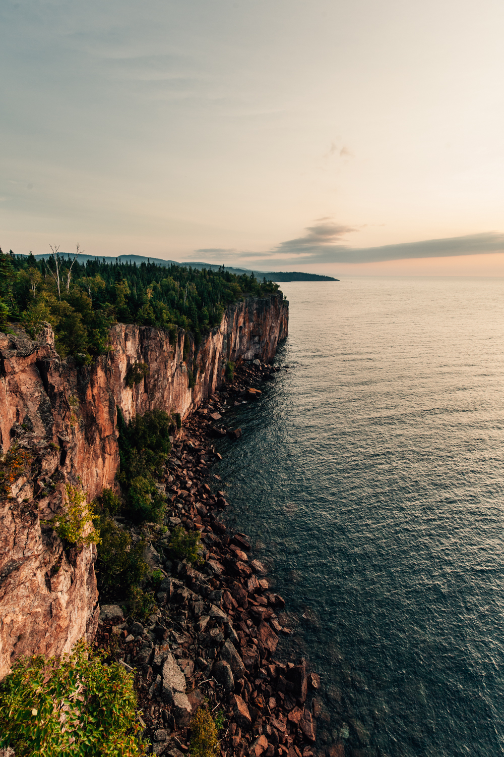
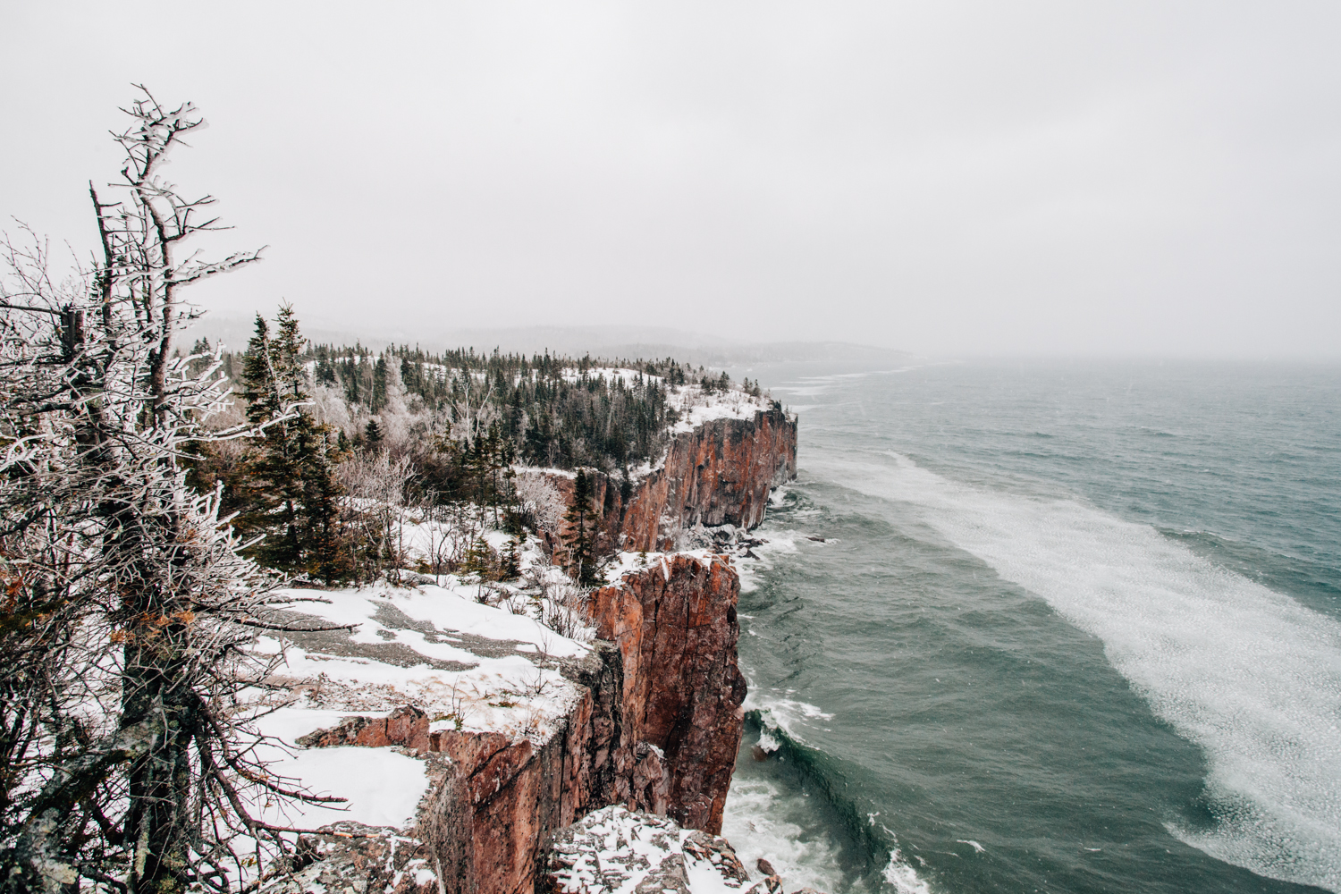
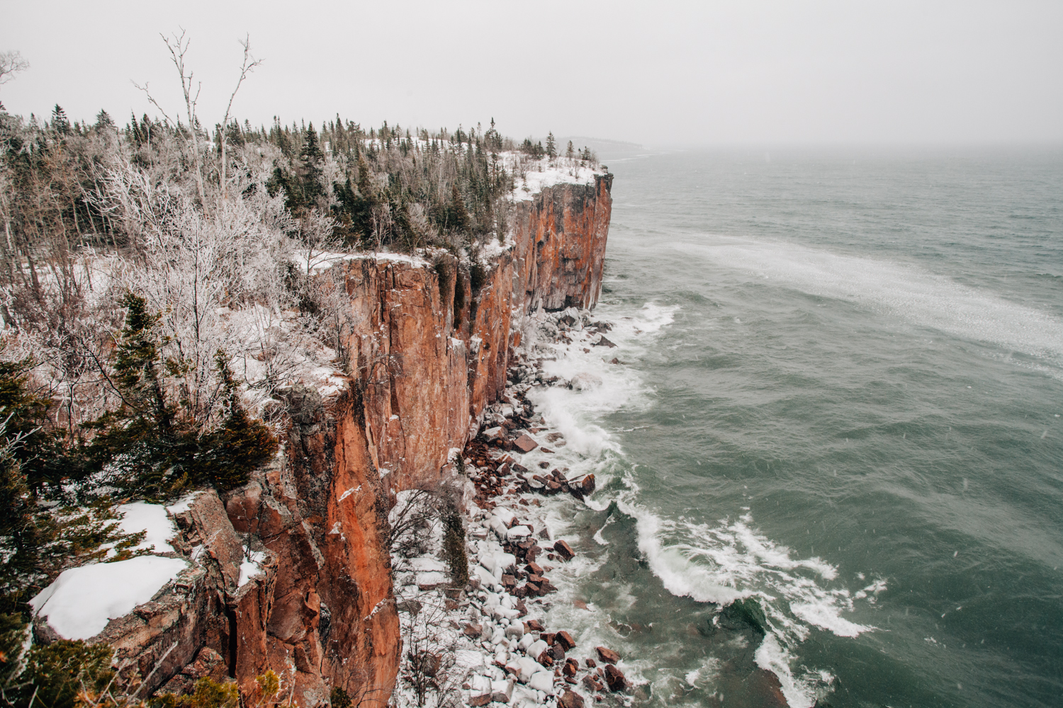
First Stop: Palisade Head:

Palisade Head is a large cliff-face located three miles north of Silver Bay at milepost 57 on Highway 61. There's a small parking lot located at the base of the hill going up to the overlook where you can park your car. Both times I've been here, the gates have been closed, so I've had to hike up the service road to the main lot instead of making the drive. Once you've gotten to the top of the hill, jump the barricade on the north side of the parking lot and follow the edge of the cliff until you find a suitable spot to take in the view. Be very careful when walking along the cliff-face as moisture in the air tends to condense on the rock and makes it incredibly slippery. Also, if you're here in the winter be extra careful, as snow can disguise the deep crevasses near the edge.
My recommendation for Palisade Head in the summer, is to get there early. Seeing sunrise here is going to be an out of body experience, I promise. As far as gear goes, any lens is going to work, I really like going wide here with my Canon 16-35 f/fL, but you could for sure get some awesome telephoto shots of the shoreline if visibility is okay.
As far as winter goes, just get these in one piece. You will for sure have this place to yourself, but it's quite the sight to see in the winter. Looks like something out of Lord of the Rings.
Summer:


Winter:

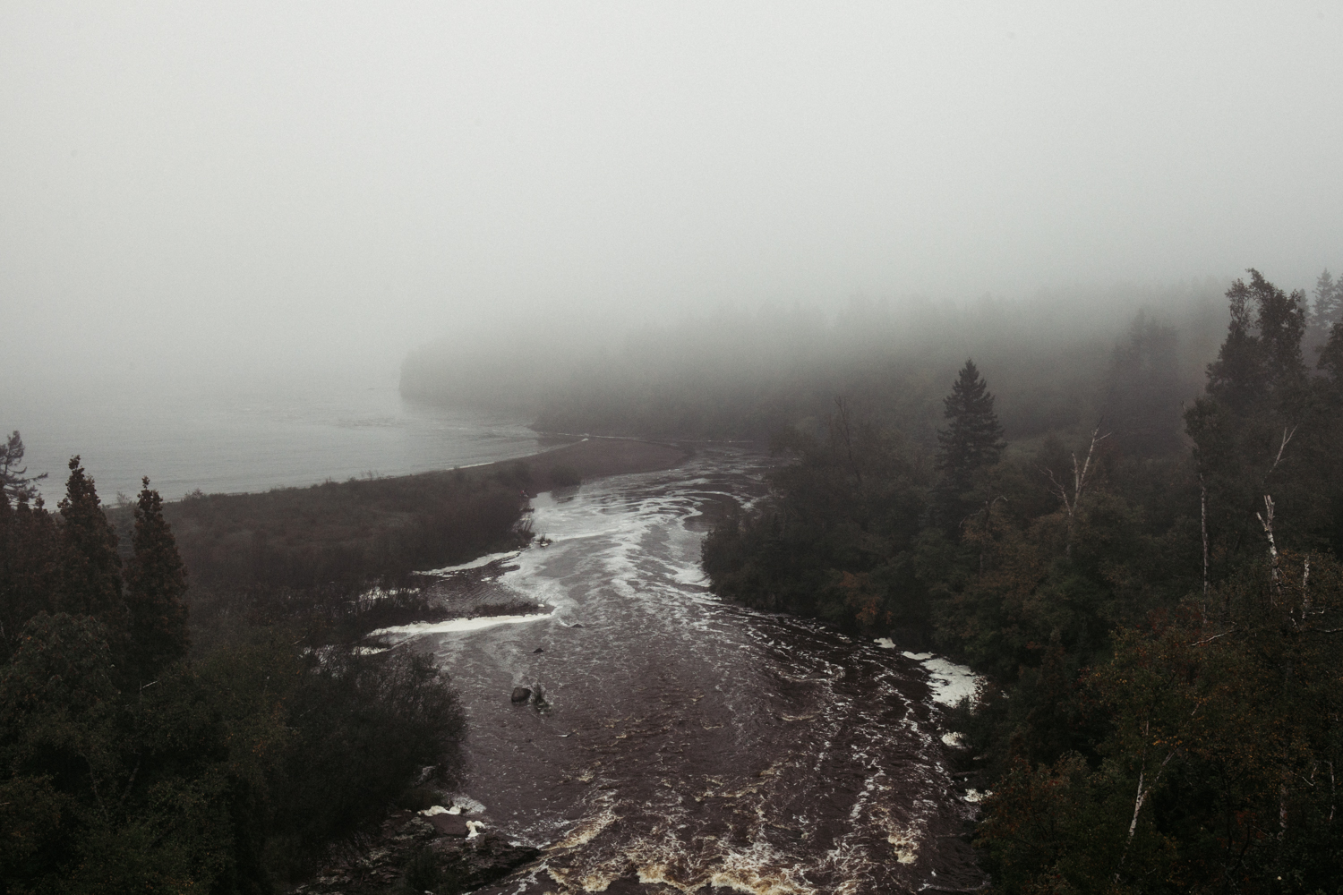
Pit Stop: Beaver Bay / Beaver River
If you're feeling hungry or need to fill up your tank after Palisade Head, I'd recommend backtracking to Beaver Bay. Coming into town from the north, you'll pass over a bridge where you'll be able to glimpse the Beaver River below. Most people drive right past this place as there really isn't any signs of a scenic overlook or anything like that. Take a right into the small parking lot next to the rest area and walk back towards the bridge. The view off of both sides of the bridge is phenomenal. Also, there's small trail leading below the bridge that's pretty neat as well.


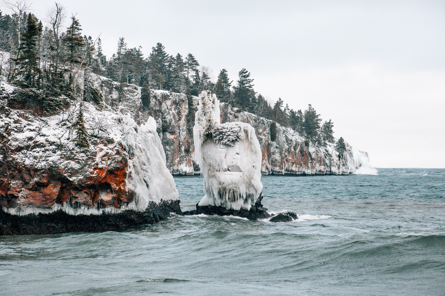
Second Stop: Shovel Point

Located in Tettegouche State Park, Shovel Point is often referred to as Little Palisade. The mini peninsula offers some very accessible trails, and some amazing views. Just miles up the road from Palisade Head, park in main lot of the visitor center and find the Shovel Point trailhead located directly behind the building. This trail follows an ascending wood path about 1/4 mile before descending towards the "point" of the land mass.
This point is actually a wooden platform perched atop of the rocky cliff-face and offers panoramic views of both sides of the shoreline.
I would recommend taking your time to explore some of the view points along the path, as these offer some of the best views looking south towards Palisade Head.
Also, make sure that on your way back to your vehicle, you take the short trail down to the beach, where you can get some awesome shots of one of the view sea stacks on the North Shore.
Summer:


Winter:


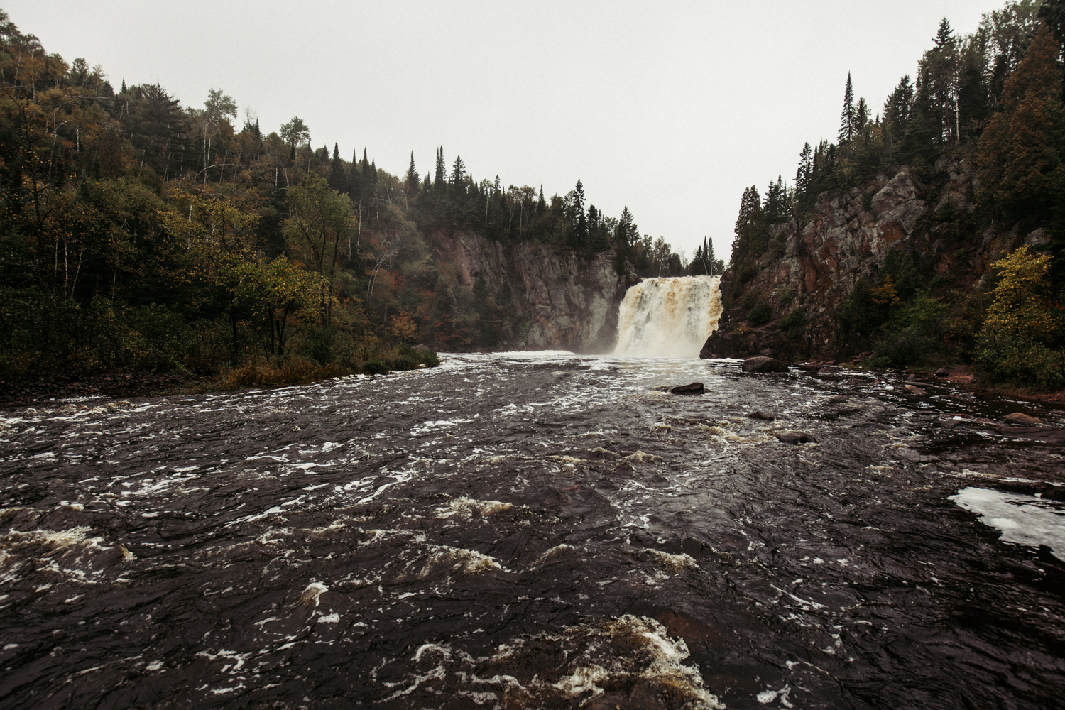
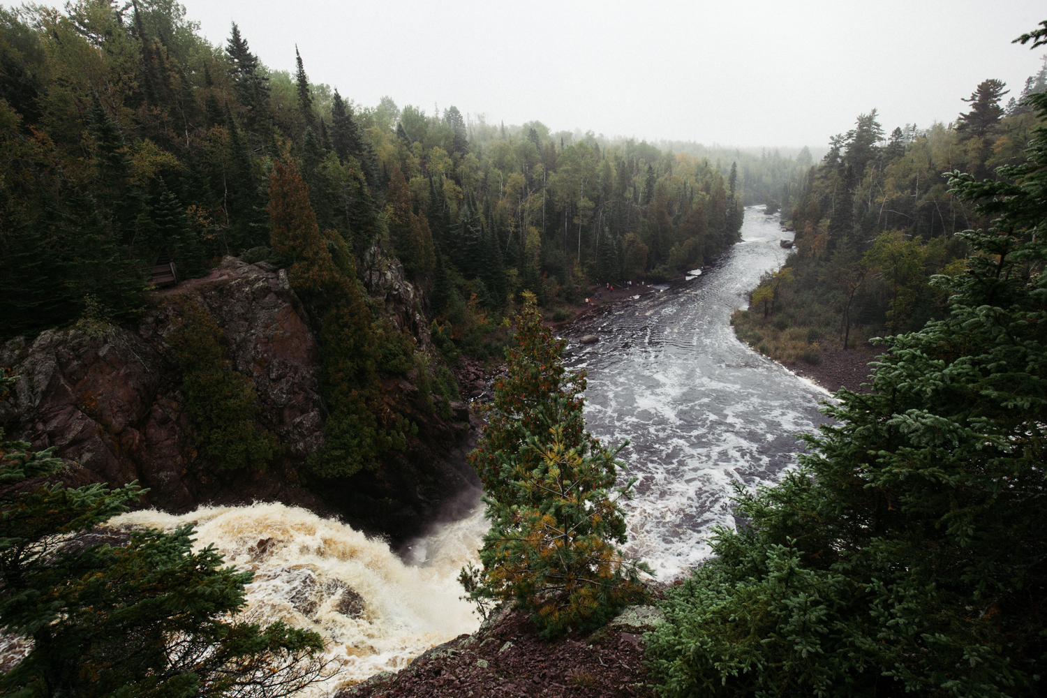
Third Stop: High Falls of the Baptism River
Also located in Tettegouche State Park, the High Falls of the Baptism River are hands down my favorite place in Minnesota. Take the State Park service road inland for about 5 miles until you reach the furthest parking lot. You'll see the trail head for the Superior Hiking Trail, which will lead you up a big hill before flattening out a bit. About a mile and a half into the trail, you'll descend a flight of wooden steps until you reach the top of High Falls. Taking a look at the tallest waterfall in Minnesota from above is definitely the best view. The waterfall is wedged in a steep valley filled with some of the tallest trees I've seen in Minnesota. Make sure to take the swinging bridge across the Baptism River to the small trail that will get you to the base of the falls.
Beware, this is not a picnic hike. The trail can be very muddy, and it's an elevation change you wouldn't expect in Minnesota
Fourth Stop: Temperance State Park

This is the only stop of the day that's not going to revolve entirely around the lake. Temperance River State Park is bisected by Highway 61 and features trails that follow the Temperance River from the Sawtooth Mountains towards it's mouth at Lake Superior. Parking is located on the shoulders of Highway 61. Once parked, you'll see a trailhead for the Superior Hiking Trail, which you will follow northwest along the Temperance River Gorge. It's a quite a sight to see and something you definitely wouldn't expect from Minnesota.
Once you've reached the terminus of the gorge, turn around a head towards the mouth of the river, where you'll find a sandy beach with some peaceful views of Lake Superior.
Summer:


Winter: That's it for winter photos. After Shovel Point, my car got stuck on the side of the road when I had pulled off onto the shoulder to look at my phone for directions. It snowed almost half a foot the day of my winter sojourn. Luckily some friendly gentleman from Manitoba pulled over and towed me out.
Fifth Stop: Split Rock Lighthouse + Gooseberry Falls

Split Rock Lighthouse:
Split Rock Lighthouse is one of the most iconic landmarks on the North Shore. Perched atop a 130 foot cliff, the 105 year old lighthouse is listed on the U.S. National Register of Historic Places and receives tens of thousands visitors every year. This place can be very busy so I'd recommend coming here as early as possible. The photos taken below were at sunrise. If you have to make a decision between sunrise here or at Palisade Head, choose Palisade Head.
Where To Go: If you have a fantastic telephoto lens, don't bother pulling into the park. There's a scenic overlook about a mile and half south of the park right off of Highway 61. If you're in the park, take the state park road south until you see the turn off for the Trail Association shelter. Take the trail behind the shelter down to the beach.


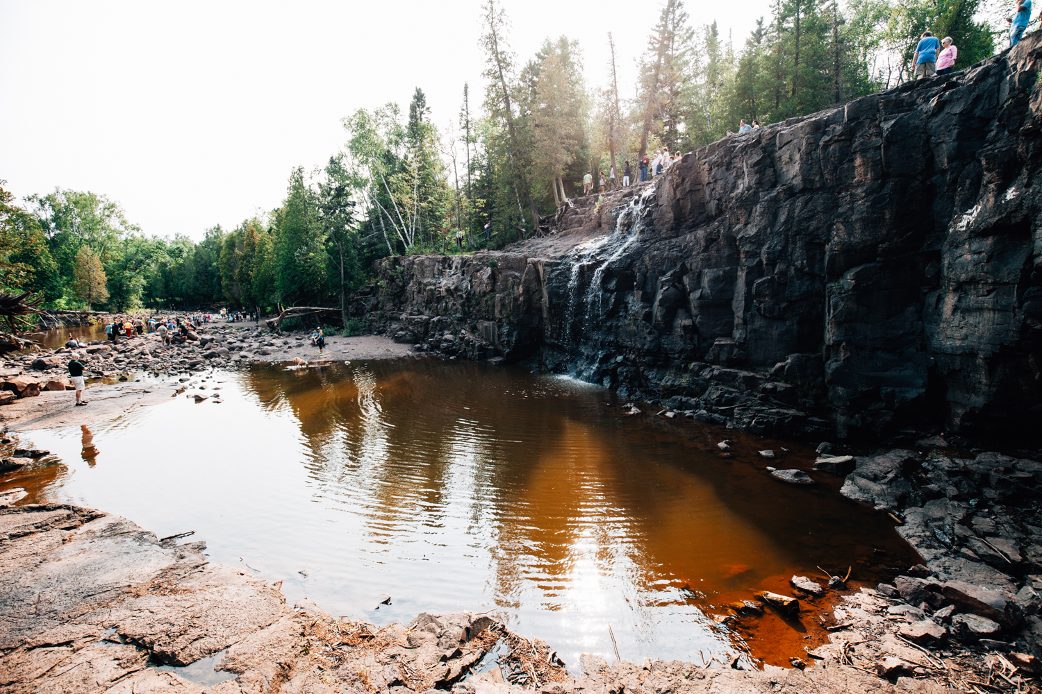
Gooseberry Falls
Gooseberry Falls is another popular stop along Highway 61. Located about 20 minutes north of Duluth, the falls are situated directly below Highway 61. This spot is extremely popular. More so than even Split Rock Lighthouse. As such, it's not a good place to take photos (lots of patch tool). The day that I visited, the parking lot was completely packed and cars extended up the service road. This stop can be missed, so only do it if you have extra time in your day.